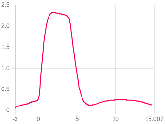
Odległość
Wybierz jednostkę odległości: Metry(m), Stopy(ft), Mile(mi) lub Kilometry(km)
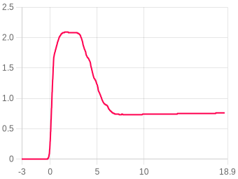
Prędkość
Wybierz jednostkę prędkości: m/s, ft/s, mph lub km/h
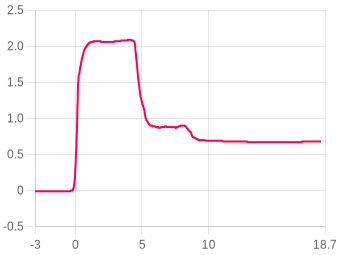
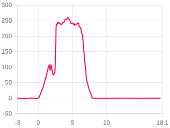
Przyspieszenie
Wybierz jednostkę przyspieszenia: m/s² lub G
Lot 2993/

Flight 2993/

Edit title
firmware 1.0
Apogeum
2.09m
4.13 s after launch
Maks. wznoszenie
0
peak ascent
Maks. podczas spalania
0
during the burn
Lądowanie
0s
touchdown 0
ZOOM TO
s
s

Save a zoom

Saves the current zoom as a zoom of interest, so anyone reading this flight can see what you want to show them by clicking a button under the chart.

Not the zoom you wanted? Close this, set the chart up as you like it, then save again.

0 of 6 saved
Pokaž zdarzenia
Pobierz
Dostosuj temp. & ciśnienie ?
Obraz
Powiększenie
Kliknij i przeciągnij lub užyj gestu
Porównaj lot ?
Własne etykiety ?
Dodaj etykiety ▾
Podsumowanie lotu

The flight, moment by moment

Liftoff
0 s
Nachylenie rampy0.00°
Thrust calc pad tilt0°
Wypalenie (pierwszy)
0 s
Wysokość0 m
Prędkość0.000
Lądowanie
0 s
Wysokość0 m
Maks. opadanie0
Apogeum
4.12 s
Wysokość2.09
Maks. nachylenie do wypalenia0.00°

Stabilność0%Słaby

Nachylenie przy wypaleniu (20%)0
20% · Launch tilt 0°
Prędkość pochylania/odchylania (30%)0
25% · Coning 0/0°/s
Coning · boost (25%)0
25% · Spin 0°/s
Prostoliniowość ciągu (15%)0
30% · Thrust 0%
Bateria & temperatura 0% → 0% · Temperatura początek 0 → 0 °C · Start po włączeniu 0s

About the stability score

Worked out from the flight log between liftoff and 80% of apogee. It is independent of the angle the altimeter was mounted at, so it measures the flight rather than the fitting.

Nachylenie przy wypaleniu (20%)20%How close to vertical it left the rod.
Prędkość pochylania/odchylania (30%)25%How much the nose swung off the rocket's own axis across the whole ascent.
Coning · boost (25%)25%The same swing during the burn, when it matters most.
Prostoliniowość ciągu (15%)30%How cleanly the motor pushed along the body.

Spin about the rocket's own axis is not counted against it — a fast, straight spin is stable. The figures beside the score are the raw measurements behind these four.

Wysokość
Apogeum2.09
Czas do apogeum4.12 s
Wysokość wypalenia0 m
Wys. maks. prędkości0 m
Wys. wyrzutu0 m
Wys. lądowania0 m
Wysokość nagrywania m
Prędkość
Maks. wznoszenie0
Maks. opadanie0
Przy wypaleniu0.000
Prędk. opadania0.000
Prędk. wyrzutu
Prędk. lądowania0.000
Przyspieszenie
Maks. podczas spalania0
Maks. wznoszenie0
Maks. opadanie0
Śr. wznoszenie
Śr. spalanie
Czasy
Wypalenie (pierwszy)0 s
Apogeum4.12 s
Možliwy wyrzut0 s
Lądowanie0 s
Kąty
Nachylenie rampy0.00°
Thrust calc pad tilt0°
Maks. nachylenie do wypalenia0.00°
Przechylenie startowe0.00°
Pochylenie startowe0.00°
Maks. obrót (spal.)0.0000 dps
Śr. obrót (spal.)0.0000 dps
Recovery
Single deploy
No dual deploy detected on this flight.
Ogólne
Data przesłania28-Sep at 09:09
Próbki danych16940
Całkowity czas nagrania18.403 s
Śr. próbki/s920.5
Liczba blokad0
Start po włączeniu0s
Oś referencyjna
Bateria & temperatura
Bateria początek0%
Bateria koniec0%
Temperatura początek0°C
Temperatura koniec0°C
⚠ Niski poziom baterii — naładuj przed następnym lotem
Notatki užytkownika
Brak notatek

Your notes for this flight

⚠These notes are public. Anyone who opens this flight can read them, including people you share the link with and anyone who finds it through search.
Bold, headings, lists and links are kept. Anything else is removed when saved.
Film Youtube
Brak filmu
Zdjęcia lotu 0
Brak zdjęć
Silniki lotu
Nie dodano silników do tego lotu
Add a motor
Powiązana rakieta
🚀
Powiąž rakietę z tym lotem

Linked flights

Connect flights that belong together: a second altimeter flown in the same rocket, or the same rocket flown again. Linked flights appear on each other’s pages.

No linked flights yet. Pick one of your flights below to link it.

Miejsce startu, data i godzina

Kliknij na mapę, aby oznaczyć miejsce startu. Przełączaj między widokiem mapy i satelity.

Imagery © Esri, Maxar, Earthstar Geographics

Kliknij na mapę · Przeciągnij, aby dostosować

Canopy height: Version 2 High Resolution Canopy Height Maps by WRI and Meta was accessed in September 2026 from https://registry.opendata.aws/dataforgood-fb-forestsv2. Meta and World Resources Institute (WRI) - 2026. Version 2 High Resolution Canopy Height Maps (CHMv2). Source imagery for CHM © 2016 Vantor, licensed under CC BY 4.0. Where that is not yet in the database: ETH Global Canopy Height 2020, CC BY 4.0, from Lang, N., Jetz, W., Schindler, K. and Wegner, J. D. (2023), A high-resolution canopy height model of the Earth, Nature Ecology & Evolution. Both reduced to height bands by Altimeter Cloud. Ground height: Terrain Tiles (Mapzen / Tilezen, on AWS Open Data), reduced into resolution tiers by Altimeter Cloud: ArcticDEM terrain data DEM(s) were created from DigitalGlobe, Inc., imagery and funded under National Science Foundation awards 1043681, 1559691, and 1542736; Australia terrain data © Commonwealth of Australia (Geoscience Australia) 2017; Austria terrain data © offene Daten Österreichs – Digitales Geländemodell (DGM) Österreich; Canada terrain data contains information licensed under the Open Government Licence – Canada; Europe terrain data produced using Copernicus data and information funded by the European Union - EU-DEM layers; Global ETOPO1 terrain data U.S. National Oceanic and Atmospheric Administration; Mexico terrain data source: INEGI, Continental relief, 2016; New Zealand terrain data Copyright 2011 Crown copyright (c) Land Information New Zealand and the New Zealand Government (All rights reserved); Norway terrain data © Kartverket; United Kingdom terrain data © Environment Agency copyright and/or database right 2015. All rights reserved; United States 3DEP (formerly NED) and global GMTED2010 and SRTM terrain data courtesy of the U.S. Geological Survey. Map and imagery credited on the view above.

Lat— Lng— Ground level—

Ground level is read from our elevation store at the marked point, the same ground the view above is drawn from.

✓ Launch site saved.
✗ Could not save. Please try again.
Animacja danych lotu

FLIGHT 2993/

2.09 Meters

ALTITUDE
0.00m
VELOCITY
0.00m/s
ACCEL
0.00G
TILT
0.00°
PITCH
0.00°
ROLL
0.00°
YAW
0.00°
TIME
0.00s
AWAITING LAUNCH
ALT
altimetercloud.com
LAUNCH T+0.00s LANDING

BURNOUT

Motor burn complete

Uwaga: Animacja lotu wymaga montażu wysokościomierza w stałej orientacji. Skalibruj czujniki dla najlepszych wyników.

Files

Where the altimeter signs its log, the file carries that signature and a tick beside it. A tick means the data is unchanged since the device wrote it, which is what a record claim needs.
Adjusted CSV2904 recalculated in your browser
The log recomputed for your own sea-level pressure and temperature. Columns: time, altitude as recorded and adjusted, raw altitude as recorded and adjusted, pressure.

This file is built here from the signed log, so it carries no signature of its own. Anyone verifying a claim should be sent to the flight page and build their own from the original.

Lot
Komentarze
Zaloguj się aby komentować.