Afstand
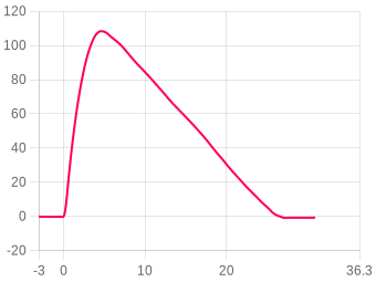
Kies de afstandseenheid: Meter(m), Voet(ft), Mijl(mi) of Kilometer(km)
Snelheid
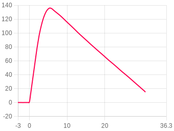
Kies de snelheidseenheid: m/s, ft/s, mph of km/h
Versnelling
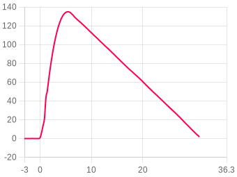
Kies de versnellingseenheid: m/s² of G

Olympus (flight 11)

Zeta Rocketry Zeta II · imported log
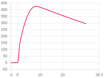
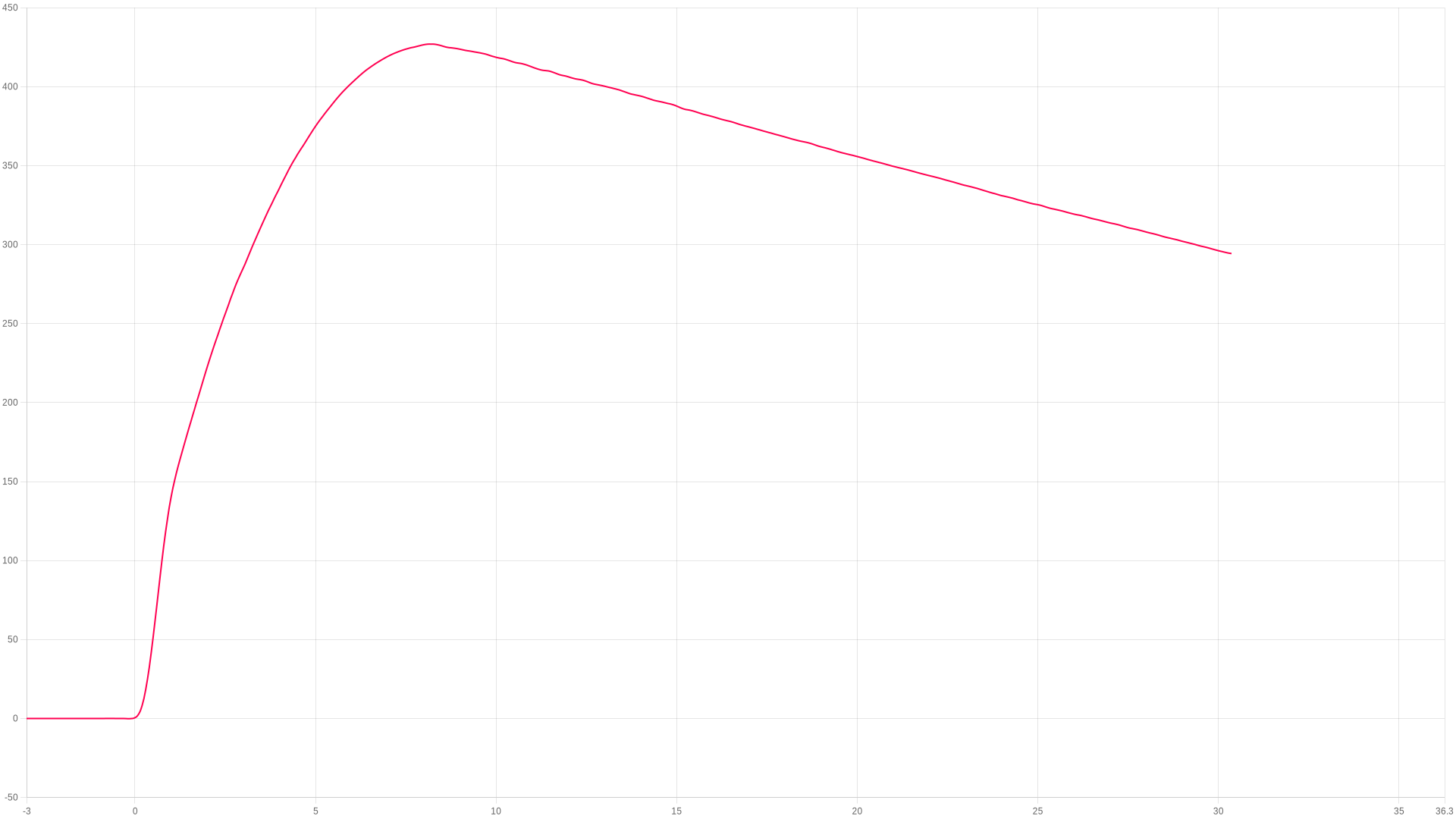
Apogeum
426.4m
8.4 s after launch
Max. stijging
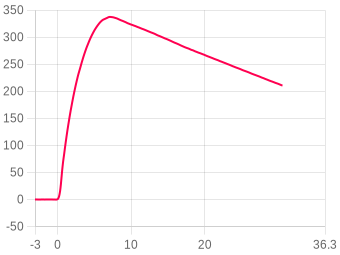
189.45m/s
peak ascent
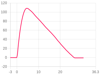
Max. tijdens verbranding
22.67G
during the burn
Recording
30.36s
log ends at 294.2 m
Zeta Rocketry Zeta II
Third party device
This log was uploaded from a Zeta Rocketry Zeta II, a non AltimeterCloud device.
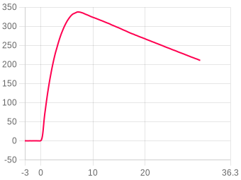
⚠The accelerometer reached the limit of its 16 G range for 550 ms during the burn, so the peak acceleration, thrust and impulse here may read low.
ZOOM TO
s
s
Toon gebeurtenissen
Downloaden
Temp. & druk aanpassen ?
Afbeelding
Zoom
Klik en sleep, of knijp op mobiel
Vlucht vergelijken ?
Something look wrong with this flight's data?
Tell us what looks wrong and we'll look into it. It helps us find and fix problems in the firmware and on the site, and we can correct this flight.
You're not logged in, so we can't let you know when we've looked into it.
Vluchtsamenvatting

The flight, moment by moment

Liftoff
0 s
Found bythe climb in its pressure
Logging20/s
Railhoek2.45°
Burnout
1 s
Hoogte139.92 m
Snelheid136.160 m/s
Ejection
7.95 s
Hoogte426.35 m
Snelheid4.29 m/s
Apogeum
8.4 s
Hoogte426.4 m
TruePath apogee426.98 m
Log ends
30.36 s
Hoogte294.25 m
Logging20/s
Hoogte
Apogeum426.4 m
Tijd tot apogeum8.4 s
Apogee, TruePath426.98 m at 8.15 s
Apogee stated by the Zeta Rocketry Zeta II426.9 m
Highest estimated apogee (device)428.3 m at 8.45 s
Highest raw altitude428.38 m at 7.95 s
Highest altitude as the Zeta Rocketry Zeta II recorded it428.5 m at 7.95 s
Highest filtered altitude426.9 m at 8.05 s
Snelheid
Max ascent, TruePath189.45 m/s at 0.65 s
Max ascent, raw (device)198.3 m/s at 0.6 s
Max descent, TruePath-6.86 m/s at 15.4 s
Typical descent rate, TruePath6.22 m/s
Velocity at burnout136.160 m/s
Max acceleration (device)23.69 G at 0.1 s
Tijden
Liftoff0 s
Burnout1 s
Ejection7.95 s
Log ends30.36 s
Algemeen
AltimeterZeta Rocketry Zeta II
Railhoek ?2.45°
Serial number10
Firmware1.3
Competitor number89040
Read out2026-09-04 12:58
Temperature assumed15.0 °C
Log formatZeta Rocketry (ZetaPost .zta)
Uploaddatum17/09/26-13:35:56
Datapunten720
Totale opnametijd35.960 s
Logging rate20/s
Imported from the log file the Zeta Rocketry Zeta II wrote. Its own figures are shown as it recorded them; the TruePath figures are worked out here on the website from its altitude column.
Something look wrong with this flight's data?
Tell us what looks wrong and we'll look into it. It helps us find and fix problems in the firmware and on the site, and we can correct this flight.
You're not logged in, so we can't let you know when we've looked into it.
Gebruikersnotities
Geen notities
Voeg dit apparaat toe aan uw account om te bewerken
Youtube-video
Geen video
Voeg dit apparaat toe aan uw account om te bewerken
Vluchtafbeeldingen 0
Geen afbeeldingen
Flown as
Rocket
None
not linked
Motor configuration
None
no motor recorded
Loaded weight
None
not entered
Vluchtmotoren
Geen motoren toegevoegd aan deze vlucht
Voeg dit apparaat toe aan uw account om te bewerken
Gekoppelde raket
Geen raket gekoppeld aan deze vlucht

Linked flights

Connect flights that belong together: a second altimeter flown in the same rocket, or the same rocket flown again. Linked flights appear on each other’s pages.

No linked flights yet.

Lanceerplaats, datum & tijd

Klik op de kaart om uw lanceerlocatie te markeren. Schakel tussen kaart- en satellietweergave.

Imagery © Esri, Maxar, Earthstar Geographics

Klik op de kaart · Sleep om aan te passen

Canopy height from the Meta and WRI High Resolution Canopy Height Maps v2 (Meta and World Resources Institute, 2026; source imagery © 2016 Vantor), used under CC BY 4.0. Ground elevation built from Terrain Tiles (Mapzen and AWS Open Data), derived from 3DEP and GMTED courtesy of the U.S. Geological Survey, SRTM courtesy of NASA, and ETOPO1 courtesy of NOAA. Map and imagery credited on the view above.

No launch site has been set for this flight.

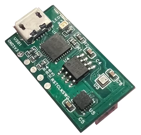
Zeta Rocketry Zeta II
Zeta Rocketry

Zeta II

Another make of altimeter. This flight was imported from its log file, and its owner calls it Zeta II - Test 1.
Serial 10Firmware 1.3Log format ZetaPost .zta

Specifications

Electronics

Microcontroller
ATSAMD21E1832-bit Cortex M0+, 48 MHz microcontroller
Accelerometer
ST LIS3DH16 g
Barometer
Bosch BMP580300 to 1250 hPa

Logging

Maximum sample rate
20 Hz
Most samples in a log
720
Longest log
36 sAt 20Hz, 6 seconds pre launch and 30 seconds from launch
Something wrong or missing?
Change what's wrong for the Zeta Rocketry Zeta II and send it. We check every suggestion before it goes on the site.
MicrocontrollerDimensionsWeight, device alone (g)Weight with its smallest battery (g)Battery voltage, lowest (V)Battery voltage, highest (V)Battery lifeMaximum sample rate (Hz)Most samples in a logLongest log (s)Longest log, how measured
Add a manual, 3D model or document
You're not logged in, so we can't let you know when it has been looked at.

Size, weight and battery

Size
15 x 25mm
Weight
1.67 g3.04 g with the smallest battery
Battery voltage
3.7 V
Battery life
2.5 hourson the smallest battery

Documents

Flights from this altimeter

4 of 49 of 9
The log

Other makes of altimeter keep their settings on the device and do not write them into the log, so there are none to show here. This is what the file itself told us.
This flight
Log formatZeta Rocketry (ZetaPost .zta)
Uploaddatum17/09/26-13:35:56
Datapunten720
Totale opnametijd35.960 s
Logging rate20 per second
ProcessingTruePath, on the website
Getting logs off the Zeta Rocketry Zeta II
Read the flight off the altimeter with ZetaPost and upload the .zta file it saves. It carries the raw pressure and all three accelerometer axes, so the altitude, burnout and thrust are worked out here. The logs we have each hold 36 seconds, so a long descent may end in the log before it lands.

Files

Where the altimeter signs its log, the file carries that signature and a tick beside it. A tick means the data is unchanged since the device wrote it, which is what a record claim needs.
CSV
2944.csv
The log as columns of text. Opens in a spreadsheet, and in every simulator that reads flight data.
67 KB
Adjusted CSV2904 recalculated in your browser
The log recomputed for your own sea-level pressure and temperature. Columns: time, altitude as recorded and adjusted, raw altitude as recorded and adjusted, pressure.

This file is built here from the signed log, so it carries no signature of its own. Anyone verifying a claim should be sent to the flight page and build their own from the original.

Custom CSVbuilt in your browser
Pick any of the chart’s data sets, the worked-out ones included, and the part of the flight to cover. Values come in the units the chart is set to.
In the file
Time span

One row for every time any chosen data set has a sample. A data set with no sample at that time is left blank rather than filled in. Built from the chart’s data, so it carries no signature.

Inloggen om te reageren.