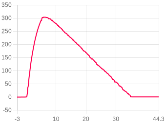
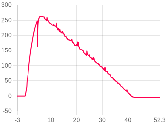
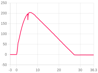
Distancia
Elija la unidad de distancia: Metros(m), Pies(ft), Millas(mi) o Kilómetros(km)
Velocidad
Elija la unidad de velocidad: m/s, ft/s, mph o km/h
Aceleración
Elija la unidad de aceleración: m/s² o G

Nano test - Klima Pegasus - B4-4

Nano V1 Rev 4 · firmware 1.64Secure logSecure logThe altimeter signed this log and it passed verification on upload, so the data is unchanged since the device wrote it.Signatures use Ed25519, which no current technology can forge.
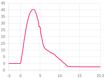
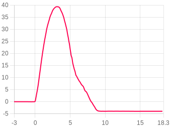
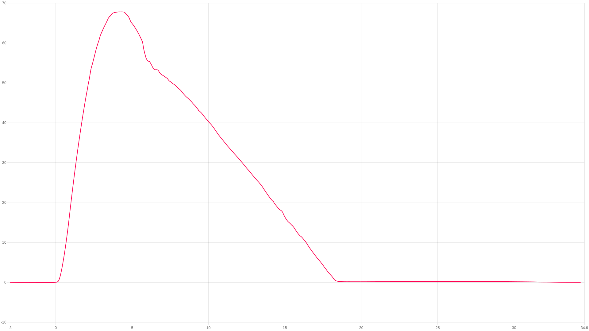
Apogeo
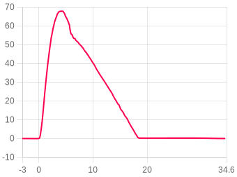
67.8m
4.33 s after launch
Máx. ascenso
33.06m/s
peak ascent
Máx. durante combustión
36.16G
during the burn
Aterrizaje
18.07s
touchdown 4.83 m/s
ZOOM TO
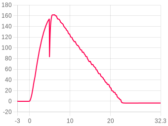
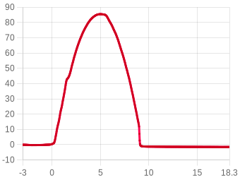
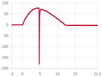
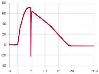
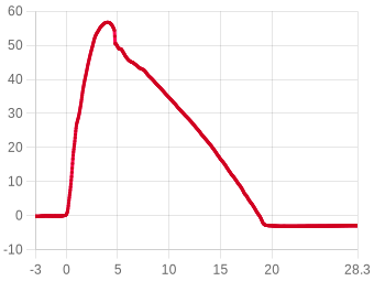
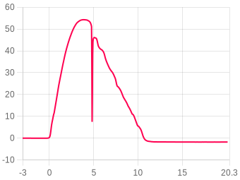
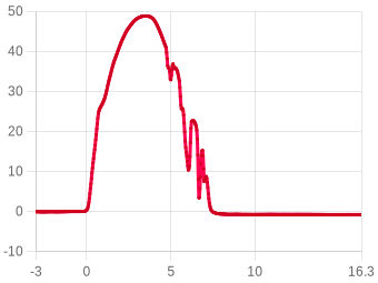
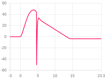
Ejection repairTesting TrueFuse and how it handles an ejection charge. The Nano was flown in the main tube exposed to the ejection pressure.3.53 to 6.47 sSwitches the chart to: Altitude, Raw altitude(m)TrueFuse testShowing TrueFuse and how it repaired the incorrect pressure-altitude line for this flight. The velocity peaked just before burnout also.-0.371 to 4.4 sSwitches the chart to: Altitude, Velocity(fused), Acceleration(total), Raw altitude(m)Landing refineWe have added to the todo list to refine the landing detection as it's picked a potential parachute flap up just before landing incorrectly.16.9 to 18.9 sSwitches the chart to: Altitude, Acceleration(total)Altimeter slipThe Nano was loose in this rocket and the gryo slip is clear to see. TrueFuse accounted for it correctly and continued.-0.248 to 1.02 sSwitches the chart to: Altitude, Gyro(X)
s
s
Mostrar eventos
Ajustar temp. & presión ?
Imagen
Zoom
Clic y arrastre, o pellizco en móvil
Comparar vuelo ?
Resumen del vuelo

The flight, moment by moment

Liftoff
0 s
Ángulo de rampa6.5°
Desvío de rampa56.97°
Fin combustión (primero)
0.93 s
Altitud17.92 m
Velocidad33.020 m/s
Launch detected
1.163 s
Altitud25.09 m
Velocidad30.63 m/s
Apogeo
4.33 s
Altitud67.8 Metros
Incl. máx. hasta fin comb.77.45°
Posible eyección
5.049 s
Altitud64.65 m
Velocidad-5.41 m/s
Aterrizaje
18.07 s
Altitud1.54 m
Máx. descenso-15.94 m/s

Estabilidad69.3%Moderado

Inclinación al apagado (20%)83.5
20% · Rail angle 6.5°
Cabeceo/guiñada (30%)66.5
25% · Coning 70.8/65.5°/s
Coning · boost (25%)69.9
25% · Spin 133.7°/s
Rectitud de empuje (15%)61.8
30% · Thrust 91.7%

Rocket information

Calculated from the flight data alone
Boost acceleration35.5 m/s²
average over the burn · 3.6 g
Coast deceleration9.7 m/s²
average · gravity plus drag
Ballistic coefficient198 kg/m²
fitted to the 3.40 s coast
Apogee lost to tilt0.43 m
flown vertical ≈ 68.2 m · from the rail angle
Chute opening peak41.76 G
largest deceleration after ejection
Average descent rate4.84 m/s
ejection to landing · 13.02 s
Batería & temperatura 86% → 81% · Temperatura inicio 28.48 → 27.49 °C · Lanzamiento tras encendido 1m 57s

About the stability score

Worked out from the flight log between liftoff and 80% of apogee. It is independent of the angle the altimeter was mounted at, so it measures the flight rather than the fitting.

Inclinación al apagado (20%)20%How close to vertical it left the rod.
Cabeceo/guiñada (30%)25%How much the nose swung off the rocket's own axis across the whole ascent.
Coning · boost (25%)25%The same swing during the burn, when it matters most.
Rectitud de empuje (15%)30%How cleanly the motor pushed along the body.

Spin about the rocket's own axis is not counted against it — a fast, straight spin is stable. The figures beside the score are the raw measurements behind these four.

Altitud
Apogeo67.8 Metros
Tiempo al apogeo4.33 s
Altitud fin combustión17.92 m
Altitud vel. máx.18.26 m
Altitud eyección64.65 m
Altitud aterrizaje1.54 m
Altitud grabación78.29 m
Velocidad
Máx. ascenso33.06 m/s
Máx. descenso-15.94 m/s
En fin combustión33.020 m/s
Vel. descenso-4.881 m/s
Vel. eyección-5.41 m/s
Vel. aterrizaje-4.828 m/s
Aceleración
Máx. durante combustión36.16 G
Máx. ascenso36.16 G
Máx. descenso41.76 G
Prom. ascenso0.24 G
Prom. combustión3.81 G
Tiempos
Fin combustión (primero)0.93 s
Apogeo4.33 s
Posible eyección5.049 s
Aterrizaje18.07 s
Ángulos
Ángulo de rampa ?6.5° ± 0.67° poco fiable, el soporte se movió
Desvío de rampa ?57° poco fiable, el soporte se movió
Incl. máx. hasta fin comb. ?77.45°
Orientación ?132.96°
Desalineación de montaje ?120.8° el ajuste de orientación parece incorrecto
Alabeo al lanzamiento134.11°
Cabeceo al lanzamiento11.65°
Giro máx. (comb.)3803.71 dps
Giro prom. (comb.)301.75 dps
Staging
Stages detected2
Burnout (refined)0.962 s
Stage S1 burnout
flip0.964 s
drag0.964 s
sig1.115 s
Stage S2 ignition2.396 s
Stage S2 burnout
flip2.553 s
drag2.606 s
sig2.705 s
Recovery
Single deploy
No dual deploy detected on this flight.
General
Fecha subida11/09/26-17:15:19
Muestras de datos8328
Tiempo total grabación43.084 s
Prom. muestras/s193.2
Número de bloqueos0
Lanzamiento tras encendido1m 57s
Eje de referenciaZ
Batería & temperatura
Batería inicio86%
Batería fin81%
Temperatura inicio28.48°C
Temperatura fin27.49°C
Notas del usuario

The first test flight of firmware 1.64 with TrueFuse 2E and Truepath-37.

It was quite windy so we went for a tiny flight on a B4-4

Very happy with the result especially as we put the altimeter in the main rocket with the ejection charge.
TEST
Añada este dispositivo a su cuenta para editar
Vídeo Youtube
Sin vídeo
Añada este dispositivo a su cuenta para editar
Imágenes del vuelo 1
Flown as
Motor configuration
Custom
1× Klima B4-4, set on this flight
Loaded weight
113.1 g
estimated, none entered

Measured burn

from this flight’s thrust
Total impulse, NFPA 1125needs the weight
rated 5.00 Ns
Burn time, NFPA 11250.92 s
0.01 to 0.93 s
Peak thrustneeds the weight
at 0.18 s
With no loaded weight the impulse would only give the motor’s rating back, so it waits for the weight. The burn time is measured either way.
Motores del vuelo
1st stage · 4s delay
1×B4-4KlimaDetails
Burn time
1.2 s
Diameter
18.00 mm
Average thrust
4 N
Max thrust
8 N
Total weight
16.30 g
Propellant weight
5.40 g
Propellant type
composite
Impulse5Ns
Max thrust8N
Burn time1.2s
Impulse classB
1st stage thrustloading curve…
Motor data by ThrustCurve.org
Añada este dispositivo a su cuenta para editar
Cohete vinculado
Active
1 photo
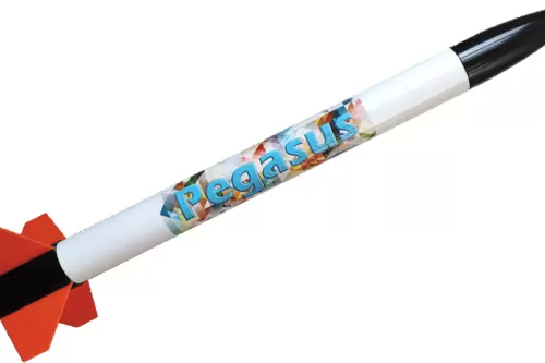
Klima Pegasus - Test Beast
Klima — Pegasus RTF
3 flights linked
Type
Kit build
Diameter
35mm
Length
495mm
Empty weight
80g
Stages
1
Recovery
Parachute
💬 No comments yet

Linked flights

Connect flights that belong together: a second altimeter flown in the same rocket, or the same rocket flown again. Linked flights appear on each other’s pages.

!The altimeters aboard disagree on apogee by 34.6%
Apogee spread67.8 – 103.6 m
#2788 · Nano V1Same flight · another altimeter103.6 mView flight →

Sitio de lanzamiento, fecha y hora

Haga clic en el mapa para marcar su sitio de lanzamiento. Cambie entre vista de mapa y satélite.

Imagery © Esri, Maxar, Earthstar Geographics

Clic en el mapa · Arrastre para ajustar

Canopy height from the Meta and WRI High Resolution Canopy Height Maps v2 (Meta and World Resources Institute, 2026; source imagery © 2016 Vantor), used under CC BY 4.0. Ground elevation built from Terrain Tiles (Mapzen and AWS Open Data), derived from 3DEP and GMTED courtesy of the U.S. Geological Survey, SRTM courtesy of NASA, and ETOPO1 courtesy of NOAA. Map and imagery credited on the view above.

Site nameHawksheadLat54.326744Lng-2.982456Ground level241.9 m · 794 ftFecha lanzamiento2026-09-07Hora lanzamiento16:30
Animación de datos

FLIGHT 2895

67.8 Meters

ALTITUDE
0.00m
VELOCITY
0.00m/s
ACCEL
0.00G
TILT
0.00°
PITCH
0.00°
ROLL
0.00°
YAW
0.00°
TIME
0.00s
AWAITING LAUNCH
ALT
altimetercloud.com
LAUNCH T+0.00s LANDING

BURNOUT

Motor burn complete

Nota: La animación de vuelo requiere que su altímetro esté montado en una orientación fija. Calibre sus sensores para mejores resultados.
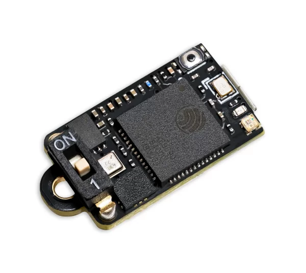
Nano V1
Revision 4
Nano V1
Este vuelo se realizó con un Nano V1.
The hardware
Versión hardwareRev 4
Versión software1.64
Última conexión11/09/26-17:15:19
Sensor presiónBosch BMP 581
Acelerómetro32G 3-axis
Giroscopio2000 dgps 3-axis

Flights from this altimeter

No other flights yet. This will fill up as you fly.

Settings, as they were for this flight

Ajustes generales del vuelo
Presión prevista
i
Set this to your local forecast pressure at sea level. This will offer you slightly improved accuracty for your flight, although it's not 100% essential every little helps!

Xcweather.co.uk is a decent place to grab pressures from for your location and time.
1013.2 mbar
Detección lanzamiento
i
This is the altitude above the launch pad altitude where the altimeter will trigger itself into recording / flight mode.

The altimeter keeps a constant average of the pressure while waiting for launch, it uses a simple algorithm and the pre-flight buffers to do this. The most recent 120 samples (~4 seconds) are ignored so your pre-trigger altitude won't effect the ground baseline.

For almost all uses we suggest keeping this on the 25 Meter (~82 feet) default settings. If you want to test your altimeter by throwing it in the air, or are planning a very low flight you may want to lower the setting.
25 meters
Sample ratio
i
The altimeter runs at 50Hz however you can record every sample or every X samples in order to extend the log time. For example if you set the ratio to 1 it will save 1:1 samples, or if you set it to 3 it will save 1 in 3 samples.
1:1:1 (400Hz)
Max samples
i
This is the maximum samples the altimeter will log per flight. When it reaches this amount it will stop and save the recording.
38000
Recording stop
i
This setting is how the altimeter decides to stop recording. You can choose either 450 (~9s) or 900 (~18s) samples stable or it will record until the max samples limit unless you press the BUTTON in Manual stop mode.

The samples stable method waits for the devices altitude not to change for the set number of samples. This is defined by not changing by more than +/- 1.0 meters for 98% of the samples, it's a reliable method to stop the recording after landing within 8-10 seconds (300 sample) or 16-20 seconds (600 sample).
Auto: 16s stable altitude
Oversampling
i
Oversampling is a internal setting of the BMP 390 pressure sensor. It is how many samples are taken for each reading. By taking multiple samples for each pressure reading the altimeter reduces noise and increases the resolution of the output.

The sensor can run at 50 samples per second in 4X mode, so we suggest leaving it in this mode as it will offer the highest accuracy.
16x Oversampling
IIR filter
i
The IIR filter is another internal sensor for the BMP390 pressure sensor. It is a Infinite impulse response filter used to enhance pressure measurement accuracy by reducing noise. It's primarily for smoothing out rapid pressure changes.

We suggest not setting this too high as it will cause delay to changes in altitude if set very high.
COEFF 7
Pressure filter
i
This filter is a software Kalman filter that runs on the altimeters processor.

The Kalman filter uses a prediction step based on a system model and then a correction step using new measurements to refine its estimate, it creates accurate most certain results from data with noise in it.
TruePath
Sample speed
i
The sample rate of the altimeter's sensors. 50Hz takes 50 samples per second, 100Hz takes 100 samples per second for higher resolution data.
400 Hz
Hybrid mode
i
When enabled, the altimeter records at full speed during ascent then switches to half speed after apogee to extend recording time during descent.
Enabled
Sync sensors
i
The filters on the pressure sensor can cause it to lag very slightly behind the Accelerometer and Gyroscope data. The Sync sensors option detects how far out of sync these sensors are. It then corrects the Acceleration and Gyroscope readings to match the pressure sensor.
ACTIVADO (46 samples / 114.88ms)
Orientation
i
This is the orientation you intend to install the Altimeter in your rocket. It's needed to ensure completly accurate angles and orientation charts and reports. Check out the Manual for more information on this.
Down (text up)
IMU filter
i
The IMU filter, or fusion filter takes the data from each axis of the Gyroscope and Accelerometer to calculate the Pitch, Roll, Yaw and tilt angle from vertical. These filters can build up some discrepency over time so it's important to calibrate your sensors to minimise this.
Madgwick 6-Axis
Launch ALP
i
This is prevention against accidental launch detection.

With this disabled the launch is based only on pressure and something that creates a low pressure can trigger the flight by accident. For example pulling your nose cone off can even trigger it.

With this enabled the rocket also needs to have seen 8 samples (0.25 seconds) of acceleration above this setting in the last 3 seconds as well as the pressure drop to trigger. There is a backup trigger of 1.05 seconds of altitude being above the launch detect setting too.

There are very few situations where this option would cause issues, so we suggest leaving it on.
2.0G
Launch lock
i
When enabled, the altimeter locks out recording for a set period after power on to prevent false triggering during setup.
DISABLED
Static temperature
i
A fixed temperature value used for altitude calculation when the external temperature sensor is disabled or not connected.
15 °C
Calibración de sensores
Compensaciones de calibración usadas en este vuelo.
Giroscopio⚠ El giroscopio no ha sido calibrado
X0.000°
Y0.000°
Z0.000°
Acelerómetro⚠ El acelerómetro no ha sido calibrado
X0.000 mG
Y0.000 mG
Z0.000 mG

Files

Where the altimeter signs its log, the file carries that signature and a tick beside it. A tick means the data is unchanged since the device wrote it, which is what a record claim needs.
CSV
2895.csv ✓ SIGNED
The log as columns of text. Opens in a spreadsheet, and in every simulator that reads flight data.
777 KB
LOG
2895.aclz ✓ SIGNED
The altimeter's own compressed log, exactly as the device wrote it. This is the file to keep for a record claim.
89 KB
WX
2895_weather.json.gz
The weather for 48 hours either side of the launch, within 15 km of the launch site: NOAA GFS every hour, at the surface and up to about 31 km, and the NOAA GEFS ensemble where this site holds it. JSON, gzip compressed. Weather data by Open-Meteo.com (CC BY 4.0) and NOAA. For 2026-09-07 16:30 local time at 54.3267, -2.9825.
1096 KB
Adjusted CSV2904 recalculated in your browser
The log recomputed for your own sea-level pressure and temperature. Columns: time, altitude as recorded and adjusted, raw altitude as recorded and adjusted, pressure.

This file is built here from the signed log, so it carries no signature of its own. Anyone verifying a claim should be sent to the flight page and build their own from the original.

Custom CSVbuilt in your browser
Pick any of the chart’s data sets, the worked-out ones included, and the part of the flight to cover. Values come in the units the chart is set to.
In the file
Time span

One row for every time any chosen data set has a sample. A data set with no sample at that time is left blank rather than filled in. Built from the chart’s data, so it carries no signature.

Inicia sesión para comentar.